Severe Thunderstorm of May 22nd 2011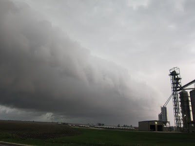

This day started out and a hot and windy clear day and the risk for severe weather was rather high.
I headed into EC Iowa first as to try and get a possible Tornado early on but the storm did not produce. On the way back a line was forming heading right for Rockford IL. Unfortunately for me it beat me home and I missed the event but did see the storm from the highway. I obviously should have stayed home or close by and won't make that mistake again.
In any event the cell from a mini bow indicating high winds and the reflectivity showed a good amount of hail too. The hail was up to quarter size at least and was wind driven from the west and piled against my garage door. The hail stripped leaves off trees. Winds were at least 60 mph or more from reports and much higher in isolated spots affected by a brief tornado.
There was also some indication of embedded tornadoes and radar showed rotation around Winnebago too ..Damage was reported in RFD too with a roof blown off a structure.

Hail risk

Refectivity

Velocity

Bowing indicating strong winds

Hail (VIL)

Tornado Paths

More Radar imagery
Click on image for larger ..


No comments:
Post a Comment